
Sălaj topographic map
Interactive map
Click on the map to display elevation.
About this map
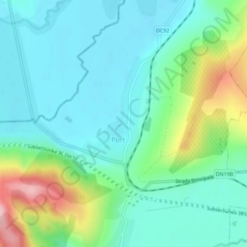
Name: Sălaj topographic map, elevation, terrain.
Location: Porț, Sălaj, Romania (47.22668 22.53858 47.24029 22.55576)
Average elevation: 203 m
Minimum elevation: 157 m
Maximum elevation: 335 m
Other topographic maps
Click on a map to view its topography, its elevation and its terrain.
Piatra Fântânele
Piatra Fântânele, Bistrița-Năsăud, 427363, Romania
Average elevation: 1,080 m
Retezat National Park
Retezat National Park, Hunedoara, Romania
Average elevation: 1,443 m