
Thank you for supporting this site ❤️
Make a donation
Make a donation
Rodges topographic map
Click on the map to display elevation.
Thank you for supporting this site ❤️
Make a donation
Make a donation
About this map
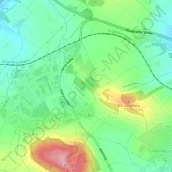
Name: Rodges topographic map, elevation, terrain.
Location: Rodges, Fulda, Landkreis Fulda, Hessen, Deutschland (50.54756 9.59286 50.56909 9.61533)
Average elevation: 306 m
Minimum elevation: 255 m
Maximum elevation: 404 m
Thank you for supporting this site ❤️
Make a donation
Make a donation
Other topographic maps
Click on a map to view its topography, its elevation and its terrain.
Fulda
Deutschland > Hessen > Landkreis Fulda > Fulda
Die Stadt Fulda liegt nahe der Mitte Deutschlands in Hessen; die Landesgrenzen zu Bayern und Thüringen liegen 15 km südsüdöstlich und 25 km östlich. Am Oberlauf des Flusses Fulda ist sie eingebettet in die Fuldaer Senke zwischen dem Fulda-Haune-Tafelland im Norden sowie den Mittelgebirgen Rhön im Osten…
Average elevation: 306 m