
Tlaxcala de Xicohténcatl topographic map
Interactive map
Click on the map to display elevation.
About this map
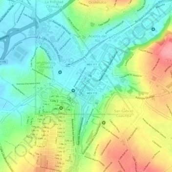
Name: Tlaxcala de Xicohténcatl topographic map, elevation, terrain.
Average elevation: 2,268 m
Minimum elevation: 2,223 m
Maximum elevation: 2,337 m
The city is located in the central Mexican highlands 2,239 metres (7,346 feet) above sea level, in a valley of the same name, from which the Popocatépetl and Iztaccíhuatl volcanoes can be seen in the distance. The main elevations in the municipality are El Cerro Ostol at 2,460 metres (8,070 feet) and El Cerro Tepepan at 2,320 metres (7,610 feet).