
Fort Mountain State Park topographic map
Interactive map
Click on the map to display elevation.
About this map
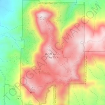
Name: Fort Mountain State Park topographic map, elevation, terrain.
Average elevation: 596 m
Minimum elevation: 242 m
Maximum elevation: 865 m
Other topographic maps
Click on a map to view its topography, its elevation and its terrain.
Iron Mountain
United States > Georgia > Murray County
Iron Mountain, Murray County, Georgia, United States
Average elevation: 362 m
Cisco
United States > Georgia > Murray County
Cisco, Murray County, Georgia, 30708, United States
Average elevation: 293 m
Eton
United States > Georgia > Murray County
Eton, Murray County, Georgia, 30724, United States
Average elevation: 236 m
Crandall
United States > Georgia > Murray County
Crandall, Murray County, Georgia, 30724, United States
Average elevation: 276 m
Chatsworth
United States > Georgia > Murray County
Chatsworth, Murray County, Georgia, United States
Average elevation: 241 m