
Thank you for supporting this site ❤️
Make a donation
Make a donation
Newchurch topographic map
Click on the map to display elevation.
Thank you for supporting this site ❤️
Make a donation
Make a donation
About this map
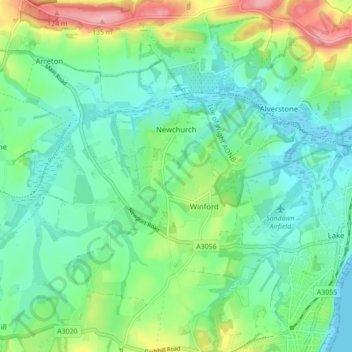
Name: Newchurch topographic map, elevation, terrain.
Location: Newchurch, Isle of Wight, England, United Kingdom (50.63002 -1.22488 50.68515 -1.17256)
Average elevation: 38 m
Minimum elevation: -1 m
Maximum elevation: 133 m
Thank you for supporting this site ❤️
Make a donation
Make a donation
Other topographic maps
Click on a map to view its topography, its elevation and its terrain.
Thank you for supporting this site ❤️
Make a donation
Make a donation
Littleton Down
United Kingdom > England > Isle of Wight > Ventnor > Bonchurch
Average elevation: 111 m
Thank you for supporting this site ❤️
Make a donation
Make a donation
Thank you for supporting this site ❤️
Make a donation
Make a donation
Thank you for supporting this site ❤️
Make a donation
Make a donation
Thank you for supporting this site ❤️
Make a donation
Make a donation
Thank you for supporting this site ❤️
Make a donation
Make a donation
Thank you for supporting this site ❤️
Make a donation
Make a donation
Thank you for supporting this site ❤️
Make a donation
Make a donation
Thank you for supporting this site ❤️
Make a donation
Make a donation
Thank you for supporting this site ❤️
Make a donation
Make a donation