
Bellapais topographic map
Click on the map to display elevation.
About this map
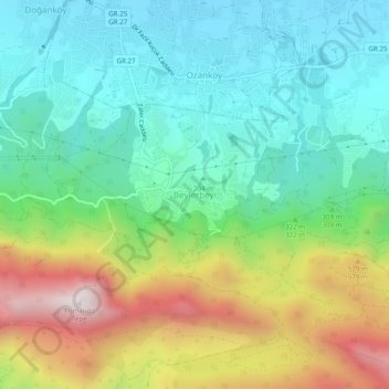
Name: Bellapais topographic map, elevation, terrain.
Location: Bellapais, Girne (Kyrenia) District, 9512, Cyprus (35.28651 33.33322 35.32651 33.37322)
Average elevation: 320 m
Minimum elevation: 31 m
Maximum elevation: 919 m
Other topographic maps
Click on a map to view its topography, its elevation and its terrain.
Πάρκο Κύπρο-Αρμένικης Φιλίας
Cyprus > Cyprus > Strovolos Municipality > Strovolos
Average elevation: 170 m
Agros
Agros (Greek: Αγρός, Turkish: Ağros) is a village built on the Troödos Mountains, in the region of Pitsilia, in southwest Cyprus, which has built amphitheatrically among high mountains at an altitude of 1100 metres with a population of approximately 1,000. Agros is one of the most interesting villages…
Average elevation: 1,109 m
Agros
Agros (Greek: Αγρός, Turkish: Ağros) is a village built on the Troödos Mountains, in the region of Pitsilia, in southwest Cyprus, which has built amphitheatrically among high mountains at an altitude of 1100 metres with a population of approximately 1,000. The village is located 45 minutes away from the…
Average elevation: 1,109 m
Dromolaxia
Cyprus > Cyprus > Δήμος Δρομολαξιάς - Μενεού > Dromolaxia - Meneou Municipality
Average elevation: 23 m