
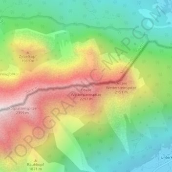
Obere Wettersteinspitze topographic map
Interactive map
Click on the map to display elevation.
About this map
Name: Obere Wettersteinspitze topographic map, elevation, terrain.
Average elevation: 1,618 m
Minimum elevation: 1,039 m
Maximum elevation: 2,426 m
Other topographic maps
Click on a map to view its topography, its elevation and its terrain.
Soiernspitze
Deutschland > Bayern > Mittenwald
Soiernspitze, Mittenwald, Landkreis Garmisch-Partenkirchen, Oberbayern, Bayern, Deutschland
Average elevation: 1,743 m
Große Arnspitze
Deutschland > Bayern > Mittenwald
Große Arnspitze, Mittenwald, Landkreis Garmisch-Partenkirchen, Oberbayern, Bayern, Deutschland
Average elevation: 1,542 m