
Kinshasa topographic map
Interactive map
Click on the map to display elevation.
About this map
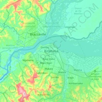
Name: Kinshasa topographic map, elevation, terrain.
Location: Kinshasa, Aketi, Kinshasa, Democratic Republic of the Congo (-4.48171 15.15260 -4.16171 15.47260)
Average elevation: 316 m
Minimum elevation: 244 m
Maximum elevation: 641 m
Geographically covering 9,965 square kilometers, Kinshasa stretches along the southern shores of the Pool Malebo, forming an expansive crescent across flat, low-lying terrain at an average altitude of about 300 meters. Situated between latitudes 4° and 5° and longitudes East 15° and 16°32, Kinshasa shares its borders with the Mai-Ndombe Province, Kwilu Province, and Kwango Province to the east; the Congo River delineates its western and northern perimeters, constituting a natural border with the Republic of the Congo; to the south lies the Kongo Central Province. Across the river sits Brazzaville, the smaller capital of the neighboring Republic of the Congo, forming the world's second-closest pair of capital cities despite being separated by a four-kilometer-wide unbridged span of the Congo River.
Other topographic maps
Click on a map to view its topography, its elevation and its terrain.
Khartoum
Democratic Republic of the Congo > Kinshasa
Khartoum, Ngiri-Ngiri, Kinshasa, Democratic Republic of the Congo
Average elevation: 297 m
Mont Amba
Democratic Republic of the Congo > Kinshasa > Mbanza Lemba
Mont Amba, Mbanza Lemba, Lemba, Kinshasa, Democratic Republic of the Congo
Average elevation: 404 m
Mont Amba
Democratic Republic of the Congo > Kinshasa
Mont Amba, Kinshasa, Democratic Republic of the Congo
Average elevation: 359 m