
Thank you for supporting this site ❤️
Make a donation
Make a donation
San Miguel topographic map
Click on the map to display elevation.
Thank you for supporting this site ❤️
Make a donation
Make a donation
About this map
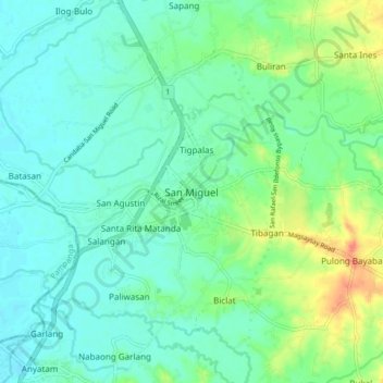
Name: San Miguel topographic map, elevation, terrain.
Location: San Miguel, Bulacan, Central Luzon, 3011, Philippines (15.10053 120.93706 15.18053 121.01706)
Average elevation: 22 m
Minimum elevation: 9 m
Maximum elevation: 55 m
Thank you for supporting this site ❤️
Make a donation
Make a donation
Other topographic maps
Click on a map to view its topography, its elevation and its terrain.