
Thank you for supporting this site ❤️
Make a donation
Make a donation
Kudawa topographic map
Click on the map to display elevation.
Thank you for supporting this site ❤️
Make a donation
Make a donation
About this map
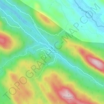
Name: Kudawa topographic map, elevation, terrain.
Location: Kudawa, Ratnapura District, Sabaragamuwa Province, Sri Lanka (6.42040 80.40082 6.46040 80.44082)
Average elevation: 425 m
Minimum elevation: 253 m
Maximum elevation: 737 m
Thank you for supporting this site ❤️
Make a donation
Make a donation
Other topographic maps
Click on a map to view its topography, its elevation and its terrain.
Sinharaja Forest Reserve
Sri Lanka > Sabaragamuwa Province > Palinda-Nuwara (Baduraliya) DS Division
Average elevation: 374 m
Thank you for supporting this site ❤️
Make a donation
Make a donation
Thank you for supporting this site ❤️
Make a donation
Make a donation
Sinharaja Forest Reserve
Sri Lanka > Sabaragamuwa Province > Palinda-Nuwara (Baduraliya) DS Division
Average elevation: 374 m
Sinharaja Forest Reserve
Sri Lanka > Sabaragamuwa Province > Palinda-Nuwara (Baduraliya) DS Division
Average elevation: 374 m
Thank you for supporting this site ❤️
Make a donation
Make a donation