
Hergenrath topographic map
Interactive map
Click on the map to display elevation.
About this map
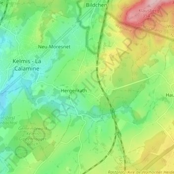
Name: Hergenrath topographic map, elevation, terrain.
Location: Hergenrath, Kelmis, Verviers, Luik, Wallonië, 4728, België (50.69153 5.99347 50.72852 6.06157)
Average elevation: 243 m
Minimum elevation: 174 m
Maximum elevation: 366 m
Other topographic maps
Click on a map to view its topography, its elevation and its terrain.
Vaalserberg
België > Luik > Verviers > Kelmis
Vaalserberg, Kelmis, Verviers, Luik, Wallonië, 4851, België
Average elevation: 277 m