
District des Franches-Montagnes topographic map
Interactive map
Click on the map to display elevation.
About this map
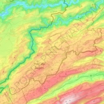
Name: District des Franches-Montagnes topographic map, elevation, terrain.
Location: District des Franches-Montagnes, Jura, Zwitserland (47.15040 6.84079 47.33579 7.17023)
Average elevation: 901 m
Minimum elevation: 384 m
Maximum elevation: 1,597 m
Other topographic maps
Click on a map to view its topography, its elevation and its terrain.
Alle
Zwitserland > Jura > Alle
Alle, District de Porrentruy, Jura, 2942, Zwitserland
Average elevation: 485 m
Porrentruy
Zwitserland > Jura > Porrentruy
Porrentruy, District de Porrentruy, Jura, 2900, Zwitserland
Average elevation: 486 m