
Make a donation
Somerset topographic map
Click on the map to display elevation.
Make a donation
Somerset
Somerset is located at 37°4′59″N 84°36′34″W / 37.08306°N 84.60944°W / 37.08306; -84.60944 (37.082966, −84.609387), and the downtown (central) part of the city is at an elevation of 974 feet above sea level. The city is located at the eastern end of Kentucky's Mississippian Plateau (or Pennyroyal Plateau); however, the micropolitan area extends eastward into the Appalachian Plateau (or Eastern Kentucky Coalfield), and northward to Kentucky's Outer Bluegrass region. Thus, the area shows variations in landforms and scenery.
Make a donation
About this map
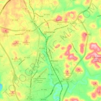
Name: Somerset topographic map, elevation, terrain.
Location: Somerset, Pulaski County, Kentucky, United States (37.03135 -84.64756 37.12006 -84.56484)
Average elevation: 295 m
Minimum elevation: 202 m
Maximum elevation: 398 m
Make a donation
Other topographic maps
Click on a map to view its topography, its elevation and its terrain.
Make a donation
Make a donation