
Bremerhaven topographic map
Interactive map
Click on the map to display elevation.
About this map
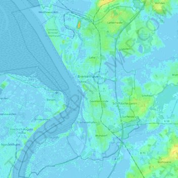
Name: Bremerhaven topographic map, elevation, terrain.
Location: Bremerhaven, Brême, 27570, Allemagne (53.47117 8.48301 53.61019 8.65918)
Average elevation: 2 m
Minimum elevation: -7 m
Maximum elevation: 20 m
Other topographic maps
Click on a map to view its topography, its elevation and its terrain.
Fischereihafen (Stadtteil)
Allemagne > Brême > Bremerhaven
Fischereihafen (Stadtteil), Stadtbezirk Bremerhaven-Süd, Bremerhaven, Brême, Allemagne
Average elevation: 1 m