
La Sarcelle topographic map
Interactive map
Click on the map to display elevation.
About this map
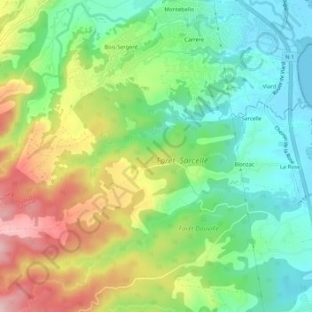
Name: La Sarcelle topographic map, elevation, terrain.
Location: La Sarcelle, Goyave, Basse-Terre, Guadeloupe, 97128, France (16.14638 -61.63199 16.16266 -61.58389)
Average elevation: 102 m
Minimum elevation: -1 m
Maximum elevation: 268 m
Other topographic maps
Click on a map to view its topography, its elevation and its terrain.
Anse de Sable
France > Guadeloupe > Goyave
Anse de Sable, Chemin Alfred Janvier, Goyave, Basse-Terre, Guadeloupe, 97128, France
Average elevation: 14 m
Rivière Bonfils
France > Guadeloupe > Goyave
Rivière Bonfils, Goyave, Basse-Terre, Guadeloupe, 97128, France
Average elevation: 102 m