
Thank you for supporting this site ❤️
Make a donation
Make a donation
Buug topographic map
Click on the map to display elevation.
Thank you for supporting this site ❤️
Make a donation
Make a donation
Buug
It has an average temperature of 26 °C (79 °F) and has an average elevation of 200 metres (660 ft) above sea level. It is away from the typhoon belt and enjoying a Type IV climate, i.e. rainfall is more or less evenly distributed throughout the year.
Thank you for supporting this site ❤️
Make a donation
Make a donation
About this map
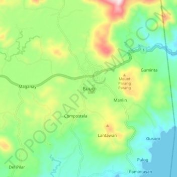
Name: Buug topographic map, elevation, terrain.
Average elevation: 196 m
Minimum elevation: 0 m
Maximum elevation: 556 m
Thank you for supporting this site ❤️
Make a donation
Make a donation
Other topographic maps
Click on a map to view its topography, its elevation and its terrain.