
Kepulauan Talaud topographic map
Interactive map
Click on the map to display elevation.
About this map
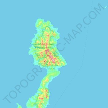
Name: Kepulauan Talaud topographic map, elevation, terrain.
Location: Kepulauan Talaud, Talaud Islands, North Sulawesi, Indonesia (4.01333 126.51333 4.65333 127.15333)
Average elevation: 18 m
Minimum elevation: 0 m
Maximum elevation: 637 m
Other topographic maps
Click on a map to view its topography, its elevation and its terrain.
Calaca
Indonesia > North Sulawesi > Manado
Calaca, Manado, North Sulawesi, Sulawesi, 95122, Indonesia
Average elevation: 11 m
Kepulauan Sangihe
Kepulauan Sangihe, North Sulawesi, Indonesia
Average elevation: 2 m
Talaud Islands
Talaud Islands, North Sulawesi, 95885, Indonesia
Average elevation: 8 m
Karakelong Island
Karakelong Island, Talaud Islands, North Sulawesi, Indonesia
Average elevation: 19 m
Bitung
Indonesia > North Sulawesi > Bitung
Bitung, North Sulawesi, 95522, Indonesia
Average elevation: 115 m
Bangka Island
Indonesia > North Sulawesi > Bitung
Bangka Island, Bitung, North Sulawesi, Indonesia
Average elevation: 35 m