
Thank you for supporting this site ❤️
Make a donation
Make a donation
Pic Long topographic map
Click on the map to display elevation.
Thank you for supporting this site ❤️
Make a donation
Make a donation
About this map
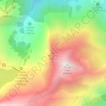
Name: Pic Long topographic map, elevation, terrain.
Average elevation: 1,879 m
Minimum elevation: 1,333 m
Maximum elevation: 2,413 m
Thank you for supporting this site ❤️
Make a donation
Make a donation
Other topographic maps
Click on a map to view its topography, its elevation and its terrain.
Gite d'Étape d'Eylie
France > Occitanie > Ariège > Sentein > Eylie d'en Haut
Average elevation: 1,248 m