
Thank you for supporting this site ❤️
Make a donation
Make a donation
Ouranoupoli topographic map
Click on the map to display elevation.
Thank you for supporting this site ❤️
Make a donation
Make a donation
About this map
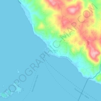
Name: Ouranoupoli topographic map, elevation, terrain.
Average elevation: 37 m
Minimum elevation: -2 m
Maximum elevation: 178 m
Thank you for supporting this site ❤️
Make a donation
Make a donation
Other topographic maps
Click on a map to view its topography, its elevation and its terrain.
Tigania Beach
Greece > Macedonia and Thrace > Chalkidiki Regional Unit > Toroni Municipal Unit
Average elevation: 11 m
Porto Koufo
Greece > Macedonia and Thrace > Chalkidiki Regional Unit > Toroni Municipal Unit > Porto Koufo
Average elevation: 61 m
Municipality of Nea Propontida
Greece > Macedonia and Thrace > Chalkidiki Regional Unit
Average elevation: 87 m