
Thank you for supporting this site ❤️
Make a donation
Make a donation
Balagares topographic map
Click on the map to display elevation.
Thank you for supporting this site ❤️
Make a donation
Make a donation
About this map
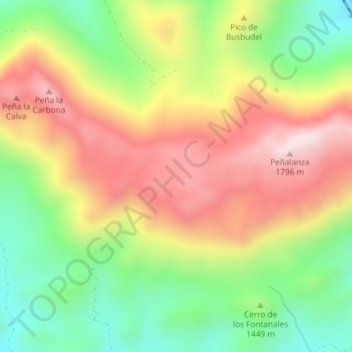
Name: Balagares topographic map, elevation, terrain.
Location: Balagares, Villamanín, León, Castille-et-León, 24690, Espagne (42.95486 -5.71635 42.97486 -5.69635)
Average elevation: 1,482 m
Minimum elevation: 1,201 m
Maximum elevation: 1,785 m
Thank you for supporting this site ❤️
Make a donation
Make a donation