
Make a donation
Wauconda topographic map
Click on the map to display elevation.
Make a donation
About this map
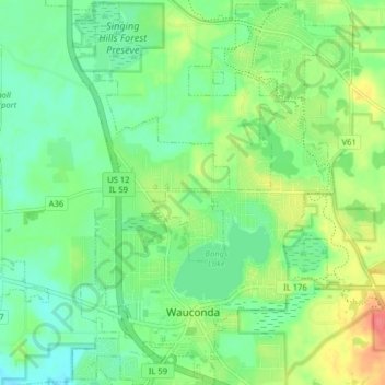
Name: Wauconda topographic map, elevation, terrain.
Location: Wauconda, Lake County, Illinois, United States (42.24767 -88.16423 42.30653 -88.10631)
Average elevation: 242 m
Minimum elevation: 222 m
Maximum elevation: 279 m
Make a donation
Other topographic maps
Click on a map to view its topography, its elevation and its terrain.
Sand Lake
United States > Illinois > Lake County > Lindenhurst > Venetian Village
Average elevation: 240 m
Make a donation
Waukegan
United States > Illinois > Lake County > Waukegan
Waukegan is located at 42°22′13″N 87°52′16″W / 42.37028°N 87.87111°W / 42.37028; -87.87111 (42.3703140, −87.8711404). Waukegan is on the shore of Lake Michigan, about 11 miles (18 km) south of the border with Wisconsin and 41 miles (66 km) north of downtown Chicago, at an elevation of…
Average elevation: 200 m
Make a donation
Bull Creek Terrace
United States > Illinois > Lake County > Beach Park > Bull Creek Terrace
Average elevation: 199 m
Make a donation
Skokie Manor
United States > Illinois > Lake County > Lake Forest > Skokie Manor
Average elevation: 208 m
Founders Park, Beach Park Il
United States > Illinois > Lake County > Beach Park > Beach Park Country Estates
Average elevation: 195 m
Make a donation