
Thank you for supporting this site ❤️
Make a donation
Make a donation
Biekhofen topographic map
Click on the map to display elevation.
Thank you for supporting this site ❤️
Make a donation
Make a donation
About this map
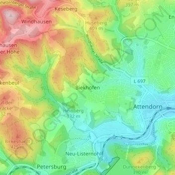
Name: Biekhofen topographic map, elevation, terrain.
Average elevation: 340 m
Minimum elevation: 252 m
Maximum elevation: 488 m
Thank you for supporting this site ❤️
Make a donation
Make a donation
Other topographic maps
Click on a map to view its topography, its elevation and its terrain.
Bremke
Deutschland > Nordrhein-Westfalen > Kreis Olpe > Attendorn > Mecklinghausen
Average elevation: 356 m