
Thank you for supporting this site ❤️
Make a donation
Make a donation
Thorne topographic map
Click on the map to display elevation.
Thank you for supporting this site ❤️
Make a donation
Make a donation
About this map
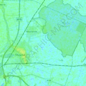
Name: Thorne topographic map, elevation, terrain.
Average elevation: 3 m
Minimum elevation: -2 m
Maximum elevation: 11 m
Thank you for supporting this site ❤️
Make a donation
Make a donation
Other topographic maps
Click on a map to view its topography, its elevation and its terrain.
Campsall
United Kingdom > England > Doncaster
Campsall is a village and former civil parish, now in the parish of Norton, in the Doncaster district, in the county of South Yorkshire, England. It lies 7 miles (11 km) to the north-west of Doncaster, at an elevation of around 50 feet above sea level. The village contains Campsall Country Park. The village…
Average elevation: 24 m