
Lockenhaus topographic map
Interactive map
Click on the map to display elevation.
About this map
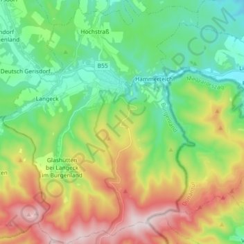
Name: Lockenhaus topographic map, elevation, terrain.
Average elevation: 492 m
Minimum elevation: 283 m
Maximum elevation: 874 m
Vor Christi Geburt war das Gebiet Teil des keltischen Königreiches Noricum und gehörte zur Umgebung der keltischen Höhensiedlung Burg auf dem Schwarzenbacher Burgberg.