
Thank you for supporting this site ❤️
Make a donation
Make a donation
Endingen topographic map
Click on the map to display elevation.
Thank you for supporting this site ❤️
Make a donation
Make a donation
About this map
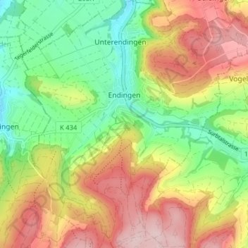
Name: Endingen topographic map, elevation, terrain.
Location: Endingen, Bezirk Zurzach, Aargau, 5304, Schweiz (47.51073 8.26296 47.55423 8.32212)
Average elevation: 477 m
Minimum elevation: 364 m
Maximum elevation: 607 m
Thank you for supporting this site ❤️
Make a donation
Make a donation
Other topographic maps
Click on a map to view its topography, its elevation and its terrain.