
Thank you for supporting this site ❤️
Make a donation
Make a donation
Singen (Hohentwiel) topographic map
Click on the map to display elevation.
Thank you for supporting this site ❤️
Make a donation
Make a donation
About this map
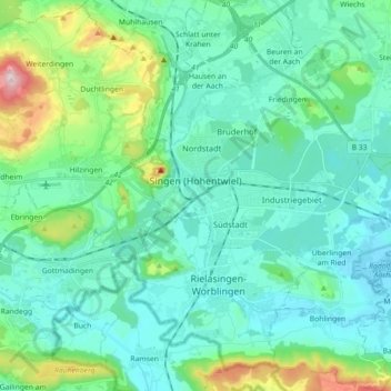
Name: Singen (Hohentwiel) topographic map, elevation, terrain.
Average elevation: 473 m
Minimum elevation: 397 m
Maximum elevation: 808 m
Thank you for supporting this site ❤️
Make a donation
Make a donation
Other topographic maps
Click on a map to view its topography, its elevation and its terrain.
Rickelshausen
Germany > Baden-Württemberg > Landkreis Konstanz > Radolfzell am Bodensee > Böhringen
Average elevation: 406 m
Thank you for supporting this site ❤️
Make a donation
Make a donation
Bleiche
Germany > Baden-Württemberg > Landkreis Konstanz > Stockach > Hindelwangen
Average elevation: 567 m
Alte Ölmühle
Germany > Baden-Württemberg > Landkreis Konstanz > Engen > Anselfingen
Average elevation: 561 m
Thank you for supporting this site ❤️
Make a donation
Make a donation