
Thank you for supporting this site ❤️
Make a donation
Make a donation
Mumbai topographic map
Click on the map to display elevation.
Thank you for supporting this site ❤️
Make a donation
Make a donation
About this map
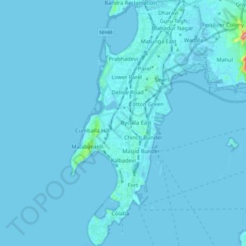
Name: Mumbai topographic map, elevation, terrain.
Location: Mumbai, Maharashtra, India (18.89396 72.79156 19.05259 72.90681)
Average elevation: 3 m
Minimum elevation: -2 m
Maximum elevation: 188 m
Thank you for supporting this site ❤️
Make a donation
Make a donation
Other topographic maps
Click on a map to view its topography, its elevation and its terrain.
Thank you for supporting this site ❤️
Make a donation
Make a donation
Tuljapur
India > Maharashtra > Tuljapur
It has an elevation of 648 metres (2125 feet).
Average elevation: 256 m