
Kavdas topographic map
Click on the map to display elevation.
About this map
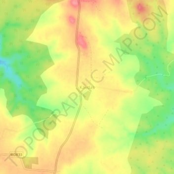
Name: Kavdas topographic map, elevation, terrain.
Location: Kavdas, Nagpur, Maharashtra, India (20.99341 78.78725 21.03341 78.82725)
Average elevation: 415 m
Minimum elevation: 369 m
Maximum elevation: 449 m
Other topographic maps
Click on a map to view its topography, its elevation and its terrain.
Pune
Pune lies on the western margin of the Deccan plateau, at an altitude of 560 m (1,840 ft) above sea level. It is on the leeward side of the Sahyadri mountain range, which forms a barrier from the Arabian Sea. It is a hilly city, with Vetal Hill rising to 800 m (2,600 ft) above sea level. The Sinhagad fort is…
Average elevation: 616 m