Geolocate

Amalner topographic map

Interactive map

Click on the map to display elevation.

About this map

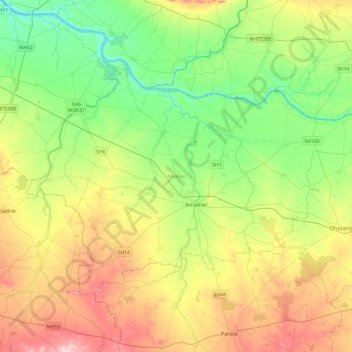
Name: Amalner topographic map, elevation, terrain.

Location: Amalner, Jalgaon, Maharashtra, India (20.92584 74.83932 21.22576 75.31722)

Average elevation: 203 m

Minimum elevation: 125 m

Maximum elevation: 334 m

Other topographic maps

Click on a map to view its topography, its elevation and its terrain.

Daund

India > Maharashtra > Daund

Average elevation: 519 m

Elphinstone Point

India > Maharashtra > Mahabaleshwar > Dare

Average elevation: 888 m

Kansai

India > Maharashtra > Shahade

Average elevation: 211 m

Nittur

India > Maharashtra > Chandgad

Average elevation: 707 m

Kayar

India > Maharashtra > Wani

Average elevation: 229 m

Kavdas

India > Maharashtra

Average elevation: 415 m

Navi Mumbai

India > Maharashtra > Thane > Navi Mumbai

Navi Mumbai (Marathi pronunciation: , is a planned city in india, situated on the west coast of the Indian subcontinent, in the Konkan division of Maharashtra state, on the mainland of western India. The city is divided into two parts, North Navi Mumbai and South Navi Mumbai, for the individual development of…

Average elevation: 30 m

Mira-Bhayander

India > Maharashtra > Mira-Bhayander

Average elevation: 40 m

Chinchwad

India > Maharashtra > Chinchwad

Average elevation: 548 m

Shirsad

India > Maharashtra > Shirsad

Average elevation: 34 m

Dapchari

India > Maharashtra > Dapchari

Average elevation: 64 m

Nagpur

India > Maharashtra > Nagpur

Average elevation: 304 m

Dharavi

India > Maharashtra > Mumbai

Average elevation: 6 m

Tuljapur

India > Maharashtra > Tuljapur

It has an elevation of 648 metres (2125 feet).

Average elevation: 256 m

Nashik

India > Maharashtra > Nashik

Average elevation: 631 m