
Thank you for supporting this site ❤️
Make a donation
Make a donation
Mahabaleshwar topographic map
Click on the map to display elevation.
Thank you for supporting this site ❤️
Make a donation
Make a donation
About this map
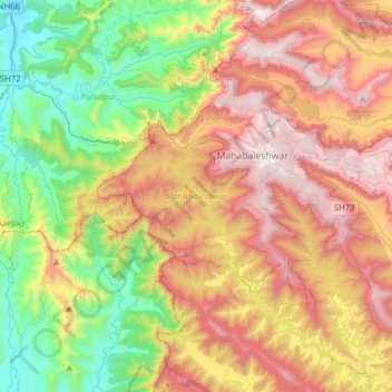
Name: Mahabaleshwar topographic map, elevation, terrain.
Location: Mahabaleshwar, Satara, Maharashtra, India (17.80619 73.53447 17.98104 73.84512)
Average elevation: 654 m
Minimum elevation: 15 m
Maximum elevation: 1,435 m
Thank you for supporting this site ❤️
Make a donation
Make a donation
Other topographic maps
Click on a map to view its topography, its elevation and its terrain.
Thank you for supporting this site ❤️
Make a donation
Make a donation
Tuljapur
India > Maharashtra > Tuljapur
It has an elevation of 648 metres (2125 feet).
Average elevation: 256 m