
Thank you for supporting this site ❤️
Make a donation
Make a donation
Cazalbarbier topographic map
Click on the map to display elevation.
Thank you for supporting this site ❤️
Make a donation
Make a donation
About this map
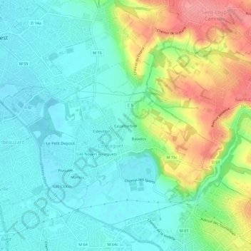
Name: Cazalbarbier topographic map, elevation, terrain.
Average elevation: 155 m
Minimum elevation: 127 m
Maximum elevation: 214 m
Thank you for supporting this site ❤️
Make a donation
Make a donation
Other topographic maps
Click on a map to view its topography, its elevation and its terrain.
Château-Mairie de Launaguet
France > Occitanie > Haute-Garonne > Launaguet > Balados
Average elevation: 148 m