Geolocate

Quảng Ninh District topographic map

Interactive map

Click on the map to display elevation.

About this map

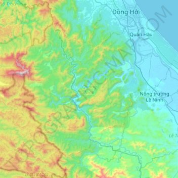
Name: Quảng Ninh District topographic map, elevation, terrain.

Location: Quảng Ninh District, Quang Binh province, Vietnam (17.07085 106.28730 17.43613 106.79671)

Average elevation: 308 m

Minimum elevation: -3 m

Maximum elevation: 1,597 m

Other topographic maps

Click on a map to view its topography, its elevation and its terrain.

Phong Nha Town

Vietnam > Quang Binh province > Bố Trạch District

Phong Nha Town, Bố Trạch District, Quảng Bình Province, Vietnam

Average elevation: 66 m

Bố Trạch District

Vietnam > Quang Binh province

Bố Trạch District, Quang Binh province, Vietnam

Average elevation: 356 m

Kiến Giang

Vietnam > Quang Binh province > Kiến Giang

Kiến Giang, Lệ Thủy District, Quang Binh province, Vietnam

Average elevation: 3 m