
Giles Conrad Park topographic map
Interactive map
Click on the map to display elevation.
About this map
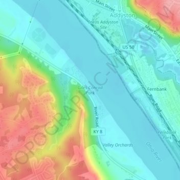
Name: Giles Conrad Park topographic map, elevation, terrain.
Average elevation: 172 m
Minimum elevation: 138 m
Maximum elevation: 250 m
Other topographic maps
Click on a map to view its topography, its elevation and its terrain.
Shawnee National Forest
United States of America > Kentucky > Tiline
Shawnee National Forest, Casey Lane, Tiline, Livingston County, Kentucky, 42083, United States of America
Average elevation: 132 m
Park Hills
United States of America > Kentucky > Park Hills
Park Hills, Kenton County, Kentucky, United States of America
Average elevation: 226 m
Barren River Lake
United States of America > Kentucky > Cedar Springs
Barren River Lake, Hurricane Shores Road, Cedar Springs, Allen County, Kentucky, 42156, United States of America
Average elevation: 193 m
Yellowbank Creek
United States of America > Kentucky > Manning Crossing
Yellowbank Creek, Manning Crossing, Breckinridge County, Kentucky, United States of America
Average elevation: 152 m
Fulton
United States of America > Kentucky > Fulton
Fulton, Fulton County, Kentucky, United States of America
Average elevation: 124 m
Stevens Knob
United States of America > Kentucky
Stevens Knob, Powell County, Kentucky, United States of America
Average elevation: 227 m
Renfro Valley
United States of America > Kentucky > Mount Vernon > Renfro Valley
Renfro Valley, Mount Vernon, Rockcastle County, Kentucky, 40473, United States of America
Average elevation: 341 m
Ellwood
United States of America > Kentucky > Ellwood
Virgie, Ellwood, Pike County, Kentucky, 41538, United States of America
Average elevation: 375 m
Clifty
United States of America > Kentucky > Clifty
Clifty, Todd County, Kentucky, 42216, United States of America
Average elevation: 225 m
Alum Springs
United States of America > Kentucky > Alum Springs
Alum Springs, Boyle County, Kentucky, 40422:40440, United States of America
Average elevation: 341 m
Marydale
United States of America > Kentucky > Marydale
Marydale, Boone County, Kentucky, 41018, United States of America
Average elevation: 267 m
Golden Ash
United States of America > Kentucky > Golden Ash
Kitts, Golden Ash, Harlan County, Kentucky, 40806, United States of America
Average elevation: 528 m
Lovely
United States of America > Kentucky > Lovely
Lovely, Martin County, Kentucky, 25674, United States of America
Average elevation: 266 m
Honeybee
United States of America > Kentucky > Honeybee
Honeybee, McCreary County, Kentucky, 42634, United States of America
Average elevation: 337 m
Ludlow
United States of America > Kentucky > Ludlow
Ludlow, Kenton County, Kentucky, 41016, United States of America
Average elevation: 182 m
Ashbrook
United States of America > Kentucky > Ashbrook
Ashbrook, Anderson County, Kentucky, United States of America
Average elevation: 239 m
Raley Ford
United States of America > Kentucky > Raley Ford
Raley Ford, Allen County, Kentucky, United States of America
Average elevation: 183 m
Murray Hill
United States of America > Kentucky > Murray Hill
Murray Hill, Jefferson County, Kentucky, United States of America
Average elevation: 194 m
Claryville
United States of America > Kentucky > Claryville
Claryville, Campbell County, Kentucky, United States of America
Average elevation: 217 m
Stonewall Estates
United States of America > Kentucky > Lexington > Stonewall Estates
Stonewall Estates, Lexington, Fayette County, Kentucky, 40390:40513, United States of America
Average elevation: 301 m
Daniel Boone
United States of America > Kentucky > Daniel Boone
Daniel Boone, Hopkins County, Kentucky, 42442, United States of America
Average elevation: 149 m