
Thank you for supporting this site ❤️
Make a donation
Make a donation
Doigt du Mont Perdu topographic map
Click on the map to display elevation.
Thank you for supporting this site ❤️
Make a donation
Make a donation
About this map
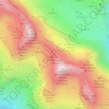
Name: Doigt du Mont Perdu topographic map, elevation, terrain.
Location: Doigt du Mont Perdu, Sobrarbe, Huesca, Aragon, Espagne (42.67904 0.03153 42.67914 0.03163)
Average elevation: 2,829 m
Minimum elevation: 2,270 m
Maximum elevation: 3,341 m
Thank you for supporting this site ❤️
Make a donation
Make a donation
Other topographic maps
Click on a map to view its topography, its elevation and its terrain.
Boltaña
Un peu plus loin, sur un promontoire, au dos de Margudgued, et au sud de Boltaña, est situé Sieste, à 730 mètres d’altitude, et a 28 habitants. Ces vues panoramiques sont remarquables. On aperçoit la Vallée de l’Ara qui s’étend jusqu’à Ainsa, au fond et à l’est; au nord, le Massif du Mont…
Average elevation: 860 m
Thank you for supporting this site ❤️
Make a donation
Make a donation