
Zuckerhütl topographic map
Interactive map
Click on the map to display elevation.
About this map
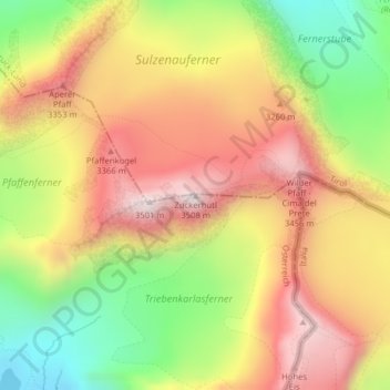
Name: Zuckerhütl topographic map, elevation, terrain.
Location: Zuckerhütl, Gemeinde Sölden, Bezirk Imst, Tyrol, Autriche (46.96426 11.15375 46.96436 11.15385)
Average elevation: 3,106 m
Minimum elevation: 2,690 m
Maximum elevation: 3,472 m
Le Zuckerhütl est un sommet des Alpes, à 3 507 m d'altitude, point culminant du massif de Stubai, en Autriche (Tyrol).
Other topographic maps
Click on a map to view its topography, its elevation and its terrain.
Wildspitze
Autriche > Tyrol > Bezirk Imst > Gemeinde Sölden
Wildspitze, Gemeinde Sölden, Bezirk Imst, Tyrol, 6458, Autriche
Average elevation: 3,284 m
Hochjoch-Hospiz
Autriche > Tyrol > Bezirk Imst > Gemeinde Sölden
Hochjoch-Hospiz, 404, Cyprian-Granbichler-Weg, Gemeinde Sölden, Bezirk Imst, Tyrol, 6458, Autriche
Average elevation: 2,596 m
Martin-Busch-Hütte
Autriche > Tyrol > Bezirk Imst > Gemeinde Sölden
Martin-Busch-Hütte, 403, Hütten Vent, Gemeinde Sölden, Bezirk Imst, Tyrol, 6458, Autriche
Average elevation: 2,681 m
Vernagthütte
Autriche > Tyrol > Bezirk Imst > Gemeinde Sölden
Vernagthütte, 402, Hütten Vent, Gemeinde Sölden, Bezirk Imst, Tyrol, 6458, Autriche
Average elevation: 2,849 m