
Thank you for supporting this site ❤️
Make a donation
Make a donation
Hofolding topographic map
Click on the map to display elevation.
Thank you for supporting this site ❤️
Make a donation
Make a donation
About this map
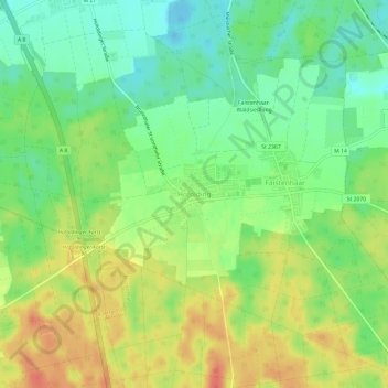
Name: Hofolding topographic map, elevation, terrain.
Average elevation: 609 m
Minimum elevation: 586 m
Maximum elevation: 635 m
Thank you for supporting this site ❤️
Make a donation
Make a donation
Other topographic maps
Click on a map to view its topography, its elevation and its terrain.
Thank you for supporting this site ❤️
Make a donation
Make a donation
Thank you for supporting this site ❤️
Make a donation
Make a donation
Ismaninger Speichersee und Fischteiche
Germany > Bavaria > Landkreis München > Unterföhring
Average elevation: 496 m
Thank you for supporting this site ❤️
Make a donation
Make a donation