
Thank you for supporting this site ❤️
Make a donation
Make a donation
Mohave Valley topographic map
Click on the map to display elevation.
Thank you for supporting this site ❤️
Make a donation
Make a donation
About this map
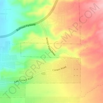
Name: Mohave Valley topographic map, elevation, terrain.
Location: Mohave Valley, Mohave County, Arizona, United States (35.05023 -114.58154 35.05484 -114.56001)
Average elevation: 233 m
Minimum elevation: 157 m
Maximum elevation: 300 m
Thank you for supporting this site ❤️
Make a donation
Make a donation
Other topographic maps
Click on a map to view its topography, its elevation and its terrain.
Fort Mojave Indian Tribe
United States > Arizona > Mohave County > Mohave Valley
Average elevation: 362 m