
Thank you for supporting this site ❤️
Make a donation
Make a donation
Nha Trang topographic map
Click on the map to display elevation.
Thank you for supporting this site ❤️
Make a donation
Make a donation
About this map
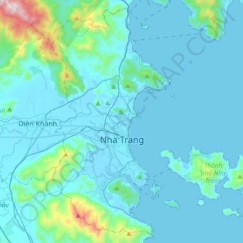
Name: Nha Trang topographic map, elevation, terrain.
Location: Nha Trang, Khánh Hòa Province, Vietnam (12.14288 109.11288 12.37991 109.37145)
Average elevation: 118 m
Minimum elevation: -2 m
Maximum elevation: 1,315 m
Thank you for supporting this site ❤️
Make a donation
Make a donation