
Make a donation
Nuremberg topographic map
Click on the map to display elevation.
Make a donation
Nuremberg
Nuremberg has an oceanic climate (Köppen Cfb) with a certain humid continental influence (Dfb), categorized in the latter by the 0 °C isotherm. The city's climate is influenced by its inland position and higher altitude. Winters are changeable, with either mild or cold weather: the average temperature is around −3 °C (27 °F) to 4 °C (39 °F), while summers are generally warm, mostly around 13 °C (55 °F) at night to 25 °C (77 °F) in the afternoon. Precipitation is evenly spread throughout the year, although February and April tend to be a bit drier whereas July tends to have more rainfall.
Make a donation
About this map
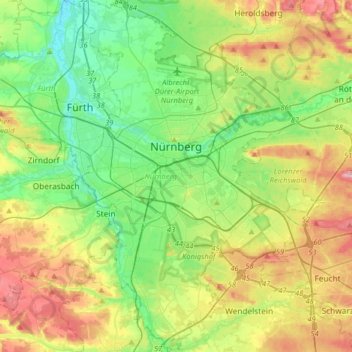
Name: Nuremberg topographic map, elevation, terrain.
Location: Nuremberg, Bavaria, Germany (49.33143 10.98873 49.54075 11.28260)
Average elevation: 336 m
Minimum elevation: 279 m
Maximum elevation: 437 m
Make a donation
Other topographic maps
Click on a map to view its topography, its elevation and its terrain.
Allgäu
The alpine regions of the Allgäu rise over 2,000 metres in elevation and are popular for winter skiing. The Allgovian area is notable for its beautiful landscapes and is popular for vacations and therapeutic stays. It is well known in Germany for its farm produce, especially dairy products including…
Average elevation: 1,087 m