
Thank you for supporting this site ❤️
Make a donation
Make a donation
Sainte-Sophie topographic map
Click on the map to display elevation.
Thank you for supporting this site ❤️
Make a donation
Make a donation
About this map
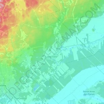
Name: Sainte-Sophie topographic map, elevation, terrain.
Average elevation: 109 m
Minimum elevation: 48 m
Maximum elevation: 335 m
Thank you for supporting this site ❤️
Make a donation
Make a donation
Other topographic maps
Click on a map to view its topography, its elevation and its terrain.
Ruisseau de la Montée du Lac Écho
Canada > Quebec > La Rivière-du-Nord > Prévost
Average elevation: 198 m