
Thank you for supporting this site ❤️
Make a donation
Make a donation
Benue State topographic map
Click on the map to display elevation.
Thank you for supporting this site ❤️
Make a donation
Make a donation
About this map
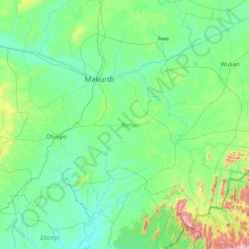
Name: Benue State topographic map, elevation, terrain.
Location: Benue State, Nigeria (6.44158 7.53051 8.15817 9.88861)
Average elevation: 182 m
Minimum elevation: 20 m
Maximum elevation: 1,940 m
Thank you for supporting this site ❤️
Make a donation
Make a donation
Other topographic maps
Click on a map to view its topography, its elevation and its terrain.