
Thank you for supporting this site ❤️
Make a donation
Make a donation
Rivière Turgeon topographic map
Click on the map to display elevation.
Thank you for supporting this site ❤️
Make a donation
Make a donation
About this map
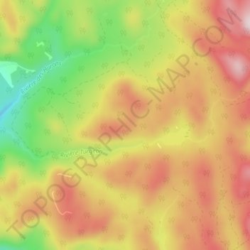
Name: Rivière Turgeon topographic map, elevation, terrain.
Average elevation: 612 m
Minimum elevation: 377 m
Maximum elevation: 823 m
Thank you for supporting this site ❤️
Make a donation
Make a donation
Other topographic maps
Click on a map to view its topography, its elevation and its terrain.
Parc National de la Jacques-Cartier
Canada > Québec > La Jacques-Cartier > Stoneham-et-Tewkesbury
Average elevation: 413 m
Thank you for supporting this site ❤️
Make a donation
Make a donation
Montagne de l'Épaule
Canada > Québec > La Jacques-Cartier > Stoneham-et-Tewkesbury
Average elevation: 348 m
Montagne de la Sautauriski
Canada > Québec > La Jacques-Cartier > Stoneham-et-Tewkesbury
Average elevation: 440 m