
Σταυρός topographic map
Interactive map
Click on the map to display elevation.
About this map
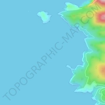
Name: Σταυρός topographic map, elevation, terrain.
Average elevation: 24 m
Minimum elevation: 0 m
Maximum elevation: 301 m
Other topographic maps
Click on a map to view its topography, its elevation and its terrain.
Σπαρτιά
Greece > Thessaly - Central Greece > Σπαρτιά
Σπαρτιά, Δήμος Στυλίδας, Regional Unit of Phthiotis, Region of Central Greece, Thessaly - Central Greece, 35013, Greece
Average elevation: 335 m
Zagora
Greece > Thessaly - Central Greece > Zagora
Zagora, Zagora - Mouresi Municipality, Regional Unit of Magnesia, Region of Thessaly, Thessaly - Central Greece, 37001, Greece
Average elevation: 523 m
Lampinou
Greece > Thessaly - Central Greece > Lampinou
Lampinou, South Pilio Municipality, Regional Unit of Magnesia, Region of Thessaly, Thessaly - Central Greece, 37012, Greece
Average elevation: 274 m
Volos
Greece > Thessaly - Central Greece > Volos
Volos, Volos Municipality, Regional Unit of Magnesia, Region of Thessaly, Thessaly - Central Greece, 38333, Greece
Average elevation: 249 m
Krannonas
Greece > Thessaly - Central Greece > Krannonas
Krannonas, Kileler Municipality, Regional Unit of Larisa, Region of Thessaly, Thessaly - Central Greece, 41500, Greece
Average elevation: 115 m
Λιάκουρα
Greece > Thessaly - Central Greece
Λιάκουρα, Δήμος Αμφίκλειας - Ελάτειας, Regional Unit of Phthiotis, Region of Central Greece, Thessaly - Central Greece, Greece
Average elevation: 2,127 m
Pindus
Greece > Thessaly - Central Greece
Pindus, Δήμος Αργιθέας, Karditsa Regional Unit, Region of Thessaly, Thessaly - Central Greece, Greece
Average elevation: 1,510 m
Dytiki Frangista
Greece > Thessaly - Central Greece > Dytiki Frangista
Dytiki Frangista, Δήμος Αγράφων, Regional Unit of Evrytania, Region of Central Greece, Thessaly - Central Greece, 36071, Greece
Average elevation: 760 m