
Make a donation
Tigray topographic map
Click on the map to display elevation.
Make a donation
Tigray
Of the 10 largest cities in Tigray, Maychew has the highest elevation at 2479 meter above sea level. Plenty of smaller towns, like Atsbi and Edaga Hamus are located at even higher elevations. Of the large cities, Humera is located at the lowest altitude (585 m).
Make a donation
About this map
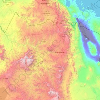
Name: Tigray topographic map, elevation, terrain.
Location: Tigray, Ethiopia (12.25628 36.44639 14.89434 39.99175)
Average elevation: 1,346 m
Minimum elevation: -126 m
Maximum elevation: 4,418 m
Make a donation
Other topographic maps
Click on a map to view its topography, its elevation and its terrain.
Make a donation
Hawassa
Hawassa (Amharic: አዋሳ; ʾäwasa, also spelled Awassa or Awasa) known historically as Adare is a city in Ethiopia, on the shores of Lake Awassa in the Great Rift Valley. It is 273 km (170 mi) south of Addis Ababa via Bishoftu, 130 km (81 mi) east of Sodo, and 75 km (47 mi) north of Dilla. The town serves…
Average elevation: 1,862 m