
Köstenberg topographic map
Interactive map
Click on the map to display elevation.
About this map
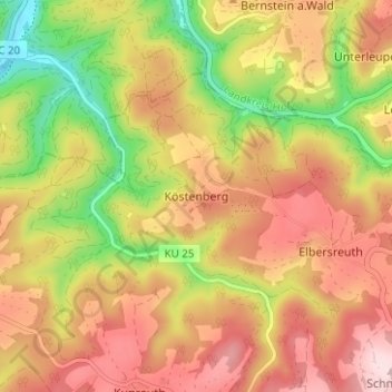
Name: Köstenberg topographic map, elevation, terrain.
Average elevation: 547 m
Minimum elevation: 384 m
Maximum elevation: 680 m
Das Dorf liegt auf einem Höhenrücken des Frankenwaldes. Südlich des Ortes im Flemersbachtal gibt es einen ehemaligen Steinbruch, der als Geotop ausgezeichnet ist. Über Anliegerwege gelangt man nach Köstenhof (0,5 km nördlich) und nach Elbersreuth (1,7 km südöstlich).
Other topographic maps
Click on a map to view its topography, its elevation and its terrain.
Melkendorf
Deutschland > Bayern > Landkreis Kulmbach > Kulmbach > Melkendorf
Melkendorf, Kulmbach, Landkreis Kulmbach, Bayern, 95326, Deutschland
Average elevation: 310 m