
Thank you for supporting this site ❤️
Make a donation
Make a donation
Catharinau topographic map
Click on the map to display elevation.
Thank you for supporting this site ❤️
Make a donation
Make a donation
About this map
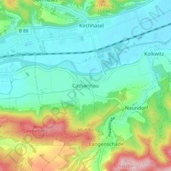
Name: Catharinau topographic map, elevation, terrain.
Average elevation: 240 m
Minimum elevation: 179 m
Maximum elevation: 389 m
Thank you for supporting this site ❤️
Make a donation
Make a donation
Other topographic maps
Click on a map to view its topography, its elevation and its terrain.
07407
Deutschland > Thüringen > Landkreis Saalfeld-Rudolstadt > Uhlstädt-Kirchhasel > Teichweiden
Average elevation: 357 m