
Thank you for supporting this site ❤️
Make a donation
Make a donation
Frasses (Lac) topographic map
Click on the map to display elevation.
Thank you for supporting this site ❤️
Make a donation
Make a donation
About this map
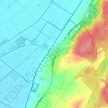
Name: Frasses (Lac) topographic map, elevation, terrain.
Location: Frasses (Lac), District du Lac, Fribourg, 3284, Suisse (46.98933 7.18733 47.00680 7.22642)
Average elevation: 462 m
Minimum elevation: 433 m
Maximum elevation: 531 m
Thank you for supporting this site ❤️
Make a donation
Make a donation
Other topographic maps
Click on a map to view its topography, its elevation and its terrain.