Lochwinnoch topographic map
Interactive map
Click on the map to display elevation.
About this map
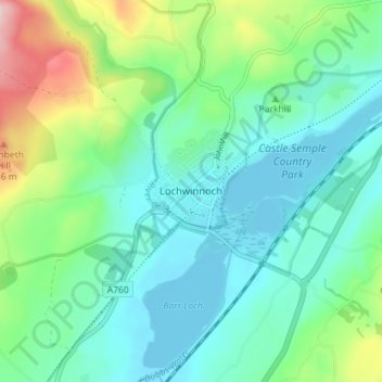
Name: Lochwinnoch topographic map, elevation, terrain.
Location: Lochwinnoch, Renfrewshire, Scotland, PA12 4DA, United Kingdom (55.77487 -4.64895 55.81487 -4.60895)
Average elevation: 81 m
Minimum elevation: 24 m
Maximum elevation: 251 m
Other topographic maps
Click on a map to view its topography, its elevation and its terrain.
Paisley
United Kingdom > Scotland > Renfrewshire
Paisley, Renfrewshire, Scotland, PA1 1DG, United Kingdom
Average elevation: 33 m
Bridge of Weir
United Kingdom > Scotland > Renfrewshire
Bridge of Weir, Renfrewshire, Scotland, PA11 3NU, United Kingdom
Average elevation: 78 m
Renfrew
United Kingdom > Scotland > Renfrewshire
Renfrew, Renfrewshire, Scotland, PA4 8TU, United Kingdom
Average elevation: 16 m
Brookfield
United Kingdom > Scotland > Renfrewshire > Johnstone > Brookfield
Brookfield, Johnstone, Renfrewshire, Scotland, PA5 8UE, United Kingdom
Average elevation: 35 m
Kilbarchan
United Kingdom > Scotland > Renfrewshire
Kilbarchan, Renfrewshire, Scotland, PA10 2JE, United Kingdom
Average elevation: 63 m
Elderslie
United Kingdom > Scotland > Renfrewshire
Elderslie, Renfrewshire, Scotland, PA5 9EP, United Kingdom
Average elevation: 61 m
Johnstone
United Kingdom > Scotland > Renfrewshire
Johnstone, Renfrewshire, Scotland, PA5 8DT, United Kingdom
Average elevation: 65 m
Howwood
United Kingdom > Scotland > Renfrewshire
Howwood, Renfrewshire, Scotland, PA9 1AP, United Kingdom
Average elevation: 94 m
Houston
United Kingdom > Scotland > Renfrewshire
Houston, Renfrewshire, Scotland, PA6 7DZ, United Kingdom
Average elevation: 42 m
Langbank
United Kingdom > Scotland > Renfrewshire
Langbank, Renfrewshire, Scotland, PA14 6YA, United Kingdom
Average elevation: 56 m
Inchinnan
United Kingdom > Scotland > Renfrewshire
Inchinnan, Renfrewshire, Scotland, PA4 9QG, United Kingdom
Average elevation: 11 m