
Corbeville topographic map
Interactive map
Click on the map to display elevation.
About this map
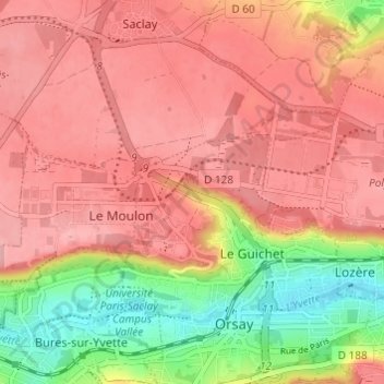
Name: Corbeville topographic map, elevation, terrain.
Average elevation: 128 m
Minimum elevation: 54 m
Maximum elevation: 169 m
Other topographic maps
Click on a map to view its topography, its elevation and its terrain.
La Boissière
France > Île-de-France > Essonne > Orsay > La Boissière
La Boissière, Orsay, Palaiseau, Essonne, Île-de-France, France métropolitaine, 91400, France
Average elevation: 127 m
La Bouvêche
France > Île-de-France > Essonne > Orsay
La Bouvêche, Orsay, Palaiseau, Essonne, Île-de-France, France métropolitaine, 91400, France
Average elevation: 130 m