
Crail topographic map
Interactive map
Click on the map to display elevation.
About this map
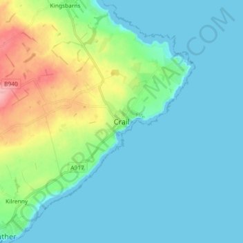
Name: Crail topographic map, elevation, terrain.
Location: Crail, Fife, Schottland, KY10 3UG, Vereinigtes Königreich (56.22068 -2.66671 56.30068 -2.58671)
Average elevation: 21 m
Minimum elevation: 0 m
Maximum elevation: 100 m
Other topographic maps
Click on a map to view its topography, its elevation and its terrain.
East Lomond
Vereinigtes Königreich > Schottland > Fife > Falkland
East Lomond, Falkland, Fife, Schottland, KY6 3HG, Vereinigtes Königreich
Average elevation: 238 m
Knock Hill
Vereinigtes Königreich > Schottland > Fife
Knock Hill, Fife, Schottland, KY12 9LP, Vereinigtes Königreich
Average elevation: 241 m
Falkland
Vereinigtes Königreich > Schottland > Fife
Falkland, Fife, Schottland, KY15 7BU, Vereinigtes Königreich
Average elevation: 133 m
St Andrews
Vereinigtes Königreich > Schottland > Fife
St Andrews, Fife, Schottland, KY16 9PA, Vereinigtes Königreich
Average elevation: 38 m